
THOUGH. MILD. 53 RIGHT NOW TO START THE MORNING TODAY IS GOING TO BE MILD AGAIN. WE’LL END UP IN THE 60S. WE’RE GOING TO DROP INTO THE 40S TOMORROW. AND THEN WE’LL ACTUALLY CLIMB BACK ABOVE NORMAL HEADING INTO THE WEEKEND. SO WE DEFINITELY HAVE SOME MORE SPRING LIKE DAYS COMING IN WITH THAT THOUGH, WE KNOW SPRING LIKE WEATHER CAN MEAN SOME RAIN SHOWERS. AND ALSO WITH THIS DRASTIC DROP IN TEMPERATURES THROUGH TOMORROW, IT’S GOING TO BRING SOME STRONGER WINDS WITH THE COLD FRONT. SO THROUGH TONIGHT WE DO HAVE A WIND ADVISORY AS THE WINDS WILL PICK UP TO 20, EVEN 30MPH SUSTAINED, AND THEN THE GUSTS COULD BE UP TO 50MPH. ESPECIALLY THIS EVENING AND TONIGHT. THAT’S WHEN WE’RE EXPECTING SOME OF THE STRONGEST WINDS. WINDS. SO BE CAREFUL WHEN YOU’RE DRIVING. IT CAN PUSH AROUND THE CAR A BIT. IT CAN ALSO BLOW AROUND UNSECURED FURNITURE OUTSIDE. SO SECURE THINGS OUTDOOR AROUND YOUR PROPERTY. AND THEN BE MINDFUL THAT SOME BRANCHES COULD BREAK. IT MAY EVEN RESULT IN A FEW POWER OUTAGES, ALTHOUGH THAT OVERALL SHOULD BE AN ISOLATED THREAT. WE’RE LOOKING AT SOME LIGHT RAIN SHOWERS ALREADY THAT JUST CAME THROUGH THE CITY. IT’S A LITTLE HEAVIER NOW TOWARDS BOWLEYS QUARTERS. MORE SHOWERS ARE OFF TO OUR WEST, SO THIS WILL BE SOMETHING WE FACE NOW. TODAY ON AND OFF. RAIN POPPING UP AT ANY TIME. SO IT DOES HELP TO HAVE AN UMBRELLA WITH YOU AT ANY POINT. TEMPERATURES THOUGH, ARE STARTING OUT IN THE 50S, SO YOU DON’T NEED AS HEAVY OF A COAT, JUST THAT WATERPROOF JACKET AS YOU’RE OUTSIDE. AND NOTICE THE RAIN SHOWERS ARE LIKELY ALL DAY TODAY, BUT ESPECIALLY TOWARDS ABOUT 9 A.M. WE’RE LIKELY TO GET GET SOME STEADIER RAIN AND THEN THE RAIN CHANCES WILL PICK UP AGAIN AROUND 3 P.M. AND 5 P.M., WHERE WE’RE GETTING ANOTHER STEADY BATCH OF RAIN. BUT TEMPERATURES WILL CLIMB INTO THE MID 60S, SO IT IS GOING TO BE VERY MILD TODAY. BUT THEN WE’LL SEE A SHARP DROP OFF THROUGH TONIGHT. SO LET’S TIME THAT OUT HERE ON THE FUTURECAST WITH SOME LIGHT SHOWERS POPPING UP HERE AND THERE THROUGHOUT THE MORNING. THEY’LL GET A LITTLE STEADIER AROUND 910 AND 11:00 WHERE THEY COULD BE BRIEFLY HEAVIER AND THEN AGAIN THROUGH THE AFTERNOON. AND EVENING. WE’LL DEAL WITH A FEW MORE ROUNDS OF SOME HEAVIER RAIN SHOWERS. AND THEN THAT WILL MOVE TO THE EAST ONCE THE RAIN STARTS TO TAPER OFF. THAT’S WHEN YOU KNOW THE COLD FRONT HAS COME THROUGH SO VERY QUICKLY. THE TEMPERATURES ARE GOING TO DROP INTO THE 40S, THEN EVENTUALLY INTO THE 30S TONIGHT. AND THAT’S WHEN WE’LL HAVE SOME OF THE STRONGEST WINDS THIS EVENING AND TONIGHT, EVEN AFTER THE RAIN HAS ENDED. SO YOU REALLY JUST HAVE TO BE A CAUTIOUS WITH THOSE WINDS, EVEN THROUGH TONIGHT, OUR SEVEN DAY FORECAST, WE HAVE AN IMPACT ADVISORY FOR TODAY BECAUSE OF THAT WIND ADVISORY OR IMPACT ALERT I SHOULD SAY TEMPERATURES ARE IN THE 60S TODAY. WE DO HAVE SOME RAIN SHOWERS COMING THROUGH ON AND OFF THROUGH TODAY. WITH THE GUSTY WINDS. IT WILL STAY GUSTY TONIGHT. WE’RE DOWN TO A LOW OF 31 TOMORROW. SUNSHINE A BRISK WIND ONLY IN THE 40S, BUT REALLY THAT’S THE ONLY ONE REALLY COLD DAY BECAUSE ALTHOUGH WE’RE NEAR 30 ON FRIDAY MORNING, WE’LL BOUNCE BACK TO 53 BY THE AFTERNOON. BUT THERE ARE SOME MORE RAIN SHOWERS FRIDAY NIGHT, SATURDAY WITH RAIN SHOWERS AND THEN ISOLATED SHOWERS SUNDAY AND MONDAY. IT WILL BE KIND OF A GLOOMY WEATHER PATTERN THROUGH THE WEEKEND INTO NEXT WEEK, BUT THE TEMPERATURES
Wind Advisory: Cold front to bring wind, rain, plummeting temps

Updated: 9:14 AM EST Feb 28, 2024
A chilly front is ready to bring main climate shifts to Maryland this week. A Wind Advisory has been issued for many of Maryland.|| Closings/Delays | Weather Advisories | Radar | Forecast | Email Alerts | Send us your pics ||Wednesday night time, the probabilities for showers will improve together with sturdy winds. The Wind Advisory begins at 6 p.m. Winds of 20-30 mph are anticipated with gusts up to 55 mph. The winds might blow round unsecure objects and branches that might lead to energy outages.Temperatures will probably be delicate Wednesday afternoon earlier than the front brings heavy rain within the early night hours. As the skies clear, temperatures will plummet to the mid-20s early Thursday morning. | LINK: MDOT SHA’s Statewide Transportation Operations Response Map Download the WBAL-TV app NOW and activate push alerts to pay attention to extreme climate warnings, hear to NOAA Weather radio, and watch WBAL-TV 11 when impending extreme climate develops.@wbaltv11 | @TTasselWBAL | @AvaWBAL | @TonyPannWBAL | @DalenciaWBAL | @ChelseaWeatherWBAL-TV 11 Maryland Weather RadarApp customers faucet right here for interactive radar.Maryland’s 7-Day Weather ForecastAlert Days vs. Impact DaysYou might even see the WBAL-TV 11 Weather Team spotlight Alert Days or Impact Days within the forecasts. Here’s what which means:An Impact Day is when climate will doubtless disrupt your regular day by day schedule or routine.An Alert Day is when there is a risk of utmost, extreme and probably life-threatening climate.Potential energy outagesStorm situations might trigger outages by pulling down tree limbs onto energy strains and different electrical supply gear. Baltimore Gas and Electric asks all clients to report their outage in any of the next methods: Online, at BGE.comBGE’s free cell app, obtainable on the Apple Store or Google Play Text message, to 69243 Phone, by calling 877-778-2222The newest outage info, together with whole quantity and common places, is offered on the BGE.com outage map.As a reminder, fallen overhead energy strains ought to by no means be approached or touched even when the strains don’t seem to be stay or sparking. Call BGE at 877-778-2222 to report fallen electrical strains, energy outages and fuel odors.Share your climate images and moviesShow us your climate images and movies, we might use them on 11 News or on-line!DIRECT UPLOAD: Use this kind to add images or video.EMAIL: Just e mail your images and video to information@wbaltv.com.ALERTS: Severe climate alerts from the WBAL-TV app: step-by-step guideCLOSINGS: See if faculties, companies or organizations have closed or delayedRADAR: Track snow, sleet or freezing rain with WBAL-TV’s interactive radarROADS: Check for crashes and backups with our interactive visitors mapWINTER: Guide: Snow security, driving hazards, energy outagesTORNADO SURVIVAL: 5 stuff you want to do nowHURRICANE PREPARATION: How to put together for hurricane season
A chilly front is ready to bring main climate shifts to Maryland this week. A Wind Advisory has been issued for many of Maryland.
|| Closings/Delays | Weather Advisories | Radar | Forecast | Email Alerts | Send us your pics ||
Wednesday night time, the probabilities for showers will improve together with sturdy winds. The Wind Advisory begins at 6 p.m. Winds of 20-30 mph are anticipated with gusts up to 55 mph. The winds might blow round unsecure objects and branches that might lead to energy outages.
Temperatures will probably be delicate Wednesday afternoon earlier than the front brings heavy rain within the early night hours. As the skies clear, temperatures will plummet to the mid-20s early Thursday morning.
This content material is imported from Twitter.
You might have the ability to discover the identical content material in one other format, or you could have the ability to discover extra info, at their website online.
| LINK: MDOT SHA’s Statewide Transportation Operations Response Map
Download the WBAL-TV app NOW and activate push alerts to pay attention to extreme climate warnings, hear to NOAA Weather radio, and watch WBAL-TV 11 when impending extreme climate develops.
@wbaltv11 | @TTasselWBAL | @AvaWBAL | @TonyPannWBAL | @DalenciaWBAL | @ChelseaWeather
WBAL-TV 11 Maryland Weather Radar
App customers faucet right here for interactive radar.

Maryland’s 7-Day Weather Forecast
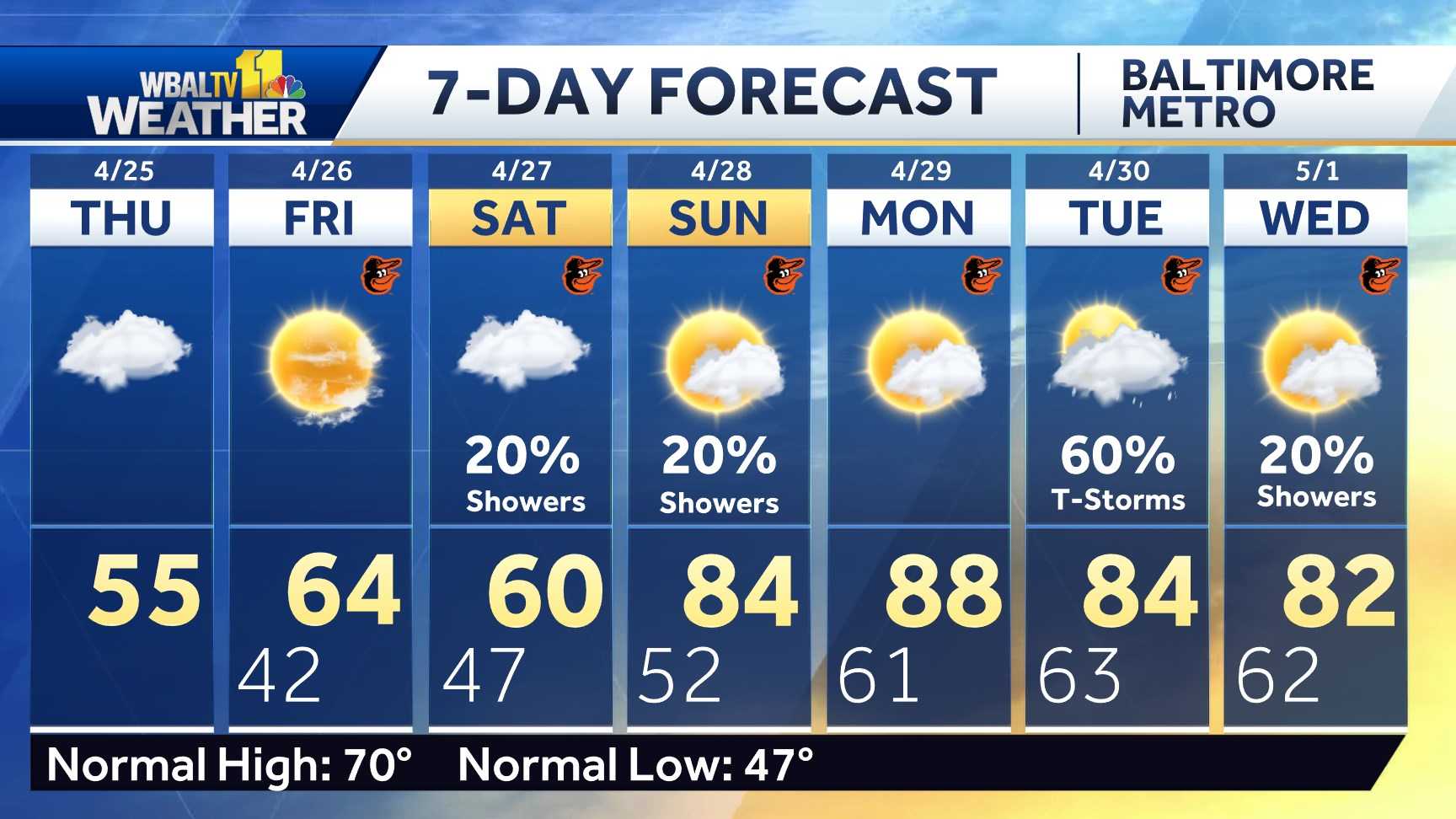
Alert Days vs. Impact Days
You might even see the WBAL-TV 11 Weather Team spotlight Alert Days or Impact Days within the forecasts. Here’s what which means:
- An Impact Day is when climate will doubtless disrupt your regular day by day schedule or routine.
- An Alert Day is when there is a risk of utmost, extreme and probably life-threatening climate.
Potential energy outages
Storm situations might trigger outages by pulling down tree limbs onto energy strains and different electrical supply gear. Baltimore Gas and Electric asks all clients to report their outage in any of the next methods:
The newest outage info, together with whole quantity and common places, is offered on the BGE.com outage map.
As a reminder, fallen overhead energy strains ought to by no means be approached or touched even when the strains don’t seem to be stay or sparking. Call BGE at 877-778-2222 to report fallen electrical strains, energy outages and fuel odors.
Share your climate images and movies
Show us your climate images and movies, we might use them on 11 News or on-line!


