
PRETTY NICE OUT FOR NOW. KIND OF COLD, BUT TOMORROW IS AN IMPACT. WEATHER DAY DALENCIA SOME PARTS OF MARYLAND UNDER A FLOOD WATCH. YES, YES, WE ARE UNDER A FLOOD WATCH OR WE HAVE BEEN ISSUED A FLOOD WATCH THAT WILL GO IN EFFECT AT AROUND 2 A.M. OVERNIGHT AND THEN LAST UNTIL THE AFTERNOON INTO SATURDAY. SO IT’S CERTAINLY SOMETHING THAT WE WANT TO PREPARE FOR AS WE’RE MOVING INTO THIS WEEKEND. CERTAINLY THOSE LOW LYING AREAS AS WELL. RIGHT NOW, RADAR IS DRY, OR AT LEAST IT LOOKS DRY. WE’RE LOOKING AT A FEW CLOUDS STARTING TO BUILD IN, AND SO WE ARE GOING TO INCREASE IN CLOUD COVER AS WE MOVE THROUGH THE REST OF THIS AFTERNOON. SO ENJOY THE DRY WEATHER WEATHER WHILE IT LASTS. LOOKING AT 43 AND AT BWI MARSHALL, 48, DOWNTOWN, 45, IN WESTMINSTER AND PRETTY MUCH STICKING AROUND THE 40S ACROSS MUCH OF THE STATE WILL WARM UP TO AROUND THE LOW 50S ACROSS MUCH OF THE AREA. A FEW WARM SPOTS COULD MAKE ITS WAY INTO THE MID 50S, BUT LOOKING AT OUR TONIGHT FORECAST, THAT’S WHEN WE’RE GOING TO BRING IN THAT RAIN. AS TEMPERATURES FALL TO THE 40S, AND THEN TOMORROW IT’S REALLY GOING TO BE A WET AND BREEZY DAY. SO HERE’S THE MAP HERE AT ONCE IS ALL SAID AND DONE. WE CAN EXPECT ANYWHERE BETWEEN 1 AND 3IN OF TOTAL RAIN. SO THOSE LOW LYING AREAS ARE GOING TO BE A PLACE WHERE WE WANT TO WATCH AS WE ARE MOVING THROUGHOUT THE DAY, HEAVY RAIN WILL START MOVING IN AFTER AROUND MIDNIGHT AND THEN WE WILL SEE IT TAPERING LATER INTO THE EVENING HOURS ON SATURDAY. LET’S LOOK IT UP HERE ON FUTURECAST. THIS IS LATER THIS EVENING. WE’RE STARTING TO SEE SOME RAIN MOVING INTO THE BALTIMORE METRO, BUT THE HEAVY RAIN WILL START MOVING IN AS WE PROGRESS OVERNIGHT AND THEN A BIG BURST OF HEAVY RAIN WILL BE MOVING IN AS WE MOVE CLOSER TO LUNCHTIME FOR SATURDAY. THAT WILL BE THE LAST BIG WAVE OF RAIN. AND THEN IT WILL TAPER OFF BY AROUND DINNERTIME ON SATURDAY. MOVING FARTHER NORTH AND EAST, LEAVING US UNDER CLOUDY SKIES UNTIL WE MOVE LATER INTO THE EVENING. HOURS INTO MIDNIGHT, AND CLEAR OUT NICELY FOR A NICE SUNNY DAY ON SUNDAY. BUT WE HAVE QUITE A BIT OF WET WEATHER AND WINDY WEATHER TO WORRY ABOUT FOR SATURDAY, SO HERE’S A WIND GUSTS UP TO 34 35 MILE PER HOUR IN BALTIMORE BY THE EVENING HOURS ON SATURDAY. THAT’S THE BACKSIDE OF THAT LOW PRESSURE SYSTEM, SO THAT MAKES EVEN SUNDAY ON THE WINDIER SIDE. BUT OF COURSE WE DO HAVE SATURDAY AS AN IMPACT DAY BECAUSE OF THE FLOOD. WATCH THE WIND AND THE RAIN. TEMPERATURES WILL BE AROUND THE MID 50S. AND THEN WE’LL STICK AROUND THE MID 50S EVEN AS WE BRING IN SOME MORE SUNNY SKIES FOR SUNDAY. SUNNY ON MONDAY AS WELL. WE’LL BRING IN OUR NEXT CHANCE OF RAIN AS WE MOVE TOWARDS THE MIDWEEK. AND YE
Impact Weather: Flood watch for Maryland mainly around I-95 corridor
Meteorologist Ava Marie says there can be a Flood Watch for Maryland beginning Friday evening and lasting via Saturday afternoon.|| Closings/Delays | Weather Advisories | Radar | Forecast | Email Alerts | Send us your pics ||The rain will develop between 11 p.m. and 1 a.m. Friday night and can rapidly change into heavy. The worst of the storm can be early Saturday morning and can taper off after 6 p.m.As the rain tapers off the winds will improve to a gentle 10-25 mph with gust as much as 35 mph potential. The solar returns on Sunday however the winds will nonetheless trigger it to be gusty.The rain would be the heaviest alongside the Interstate-95 corridor with over 2 inches of rain anticipated. Flooding can be potential on low-lying roads and streams so take warning and don’t attempt to drive via flooded roads. | LINK: MDOT SHA’s Statewide Transportation Operations Response MapDownload the WBAL-TV app NOW and activate push alerts to concentrate on extreme climate warnings, hearken to NOAA Weather radio, and watch WBAL-TV 11 when impending extreme climate develops.@wbaltv11 | @TTasselWBAL | @AvaWBAL | @TonyPannWBAL | @DalenciaWBAL | @ChelseaWeatherWBAL-TV 11 Maryland Weather RadarApp customers faucet right here for interactive radar.Maryland’s 7-Day Weather ForecastAlert Days vs. Impact DaysYou might even see the WBAL-TV 11 Weather Team spotlight Alert Days or Impact Days within the forecasts. Here’s what meaning:An Impact Day is when climate will seemingly disrupt your regular each day schedule or routine.An Alert Day is when there is a risk of utmost, extreme and presumably life-threatening climate.Potential energy outagesStorm circumstances might trigger outages by flattening tree limbs onto energy strains and different electrical supply tools. Baltimore Gas and Electric asks all clients to report their outage in any of the next methods: Online, at BGE.comBGE’s free cell app, out there on the Apple Store or Google Play Text message, to 69243 Phone, by calling 877-778-2222The newest outage info, together with complete quantity and normal places, is on the market on the BGE.com outage map.As a reminder, fallen overhead energy strains ought to by no means be approached or touched even when the strains don’t look like reside or sparking. Call BGE at 877-778-2222 to report fallen electrical strains, energy outages and fuel odors.Share your climate photographs and moviesShow us your climate photographs and movies, we could use them on 11 News or on-line!DIRECT UPLOAD: Use this manner to add photographs or video.EMAIL: Just electronic mail your photographs and video to information@wbaltv.com.ALERTS: Severe climate alerts from the WBAL-TV app: step-by-step guideCLOSINGS: See if faculties, companies or organizations have closed or delayedRADAR: Track snow, sleet or freezing rain with WBAL-TV’s interactive radarROADS: Check for crashes and backups with our interactive visitors mapWINTER: Guide: Snow security, driving hazards, energy outagesTORNADO SURVIVAL: 5 issues you want to do nowHURRICANE PREPARATION: How to organize for hurricane season
Meteorologist Ava Marie says there can be a Flood Watch for Maryland beginning Friday evening and lasting via Saturday afternoon.
|| Closings/Delays | Weather Advisories | Radar | Forecast | Email Alerts | Send us your pics ||
The rain will develop between 11 p.m. and 1 a.m. Friday night and can rapidly change into heavy. The worst of the storm can be early Saturday morning and can taper off after 6 p.m.
As the rain tapers off the winds will improve to a gentle 10-25 mph with gust as much as 35 mph potential. The solar returns on Sunday however the winds will nonetheless trigger it to be gusty.
The rain would be the heaviest alongside the Interstate-95 corridor with over 2 inches of rain anticipated. Flooding can be potential on low-lying roads and streams so take warning and don’t attempt to drive via flooded roads.
This content material is imported from Twitter.
You could possibly discover the identical content material in one other format, otherwise you could possibly discover extra info, at their website.
| LINK: MDOT SHA’s Statewide Transportation Operations Response Map
Download the WBAL-TV app NOW and activate push alerts to concentrate on extreme climate warnings, hearken to NOAA Weather radio, and watch WBAL-TV 11 when impending extreme climate develops.
@wbaltv11 | @TTasselWBAL | @AvaWBAL | @TonyPannWBAL | @DalenciaWBAL | @ChelseaWeather
WBAL-TV 11 Maryland Weather Radar
App customers faucet right here for interactive radar.
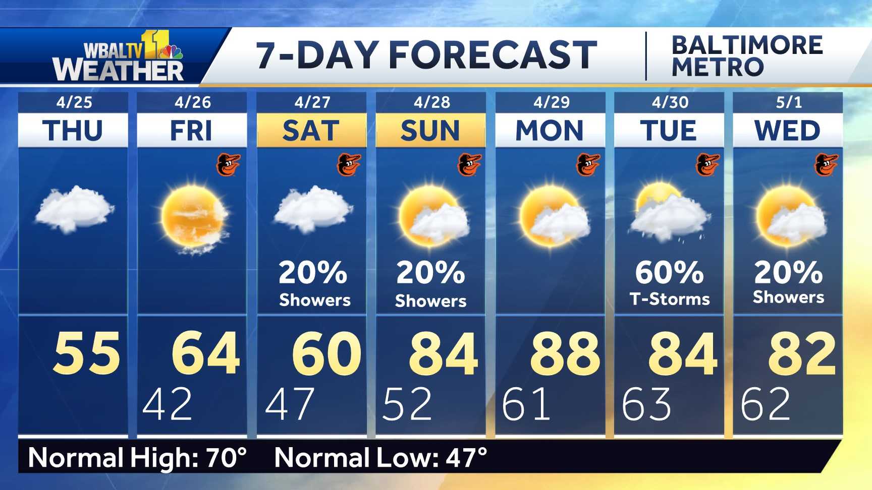
Maryland’s 7-Day Weather Forecast
Alert Days vs. Impact Days
You might even see the WBAL-TV 11 Weather Team spotlight Alert Days or Impact Days within the forecasts. Here’s what meaning:
- An Impact Day is when climate will seemingly disrupt your regular each day schedule or routine.
- An Alert Day is when there is a risk of utmost, extreme and presumably life-threatening climate.
Potential energy outages
Storm circumstances might trigger outages by flattening tree limbs onto energy strains and different electrical supply tools. Baltimore Gas and Electric asks all clients to report their outage in any of the next methods:
The newest outage info, together with complete quantity and normal places, is on the market on the BGE.com outage map.
As a reminder, fallen overhead energy strains ought to by no means be approached or touched even when the strains don’t look like reside or sparking. Call BGE at 877-778-2222 to report fallen electrical strains, energy outages and fuel odors.
Share your climate photographs and movies
Show us your climate photographs and movies, we could use them on 11 News or on-line!


